


cheval noir

oliviergau
User
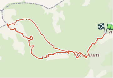

Length
16.5 km

Max alt
2794 m

Uphill gradient
1542 m
Km-Effort
37 km

Min alt
1390 m

Downhill gradient
1536 m
Boucle
Yes
Creation date :
2019-05-12 20:06:20.296
Updated on :
2019-05-12 20:06:20.296
--
Difficulty : Unknown

FREE GPS app for hiking
 SityTrail
IGN / Geographical institutes
SityTrail Plus
The world is yours!
About
Trail Touring skiing of 16.5 km to be discovered at Auvergne-Rhône-Alpes, Savoy, Les Belleville. This trail is proposed by oliviergau.
Positioning
Country:
France
Region :
Auvergne-Rhône-Alpes
Department/Province :
Savoy
Municipality :
Les Belleville
Location:
Saint-Jean-de-Belleville
Start:(Dec)
Start:(UTM)
301881 ; 5032512 (32T) N.
Comments